You will find on this repository the jupyter notebook of the processing chain developed with the open-source software GRASS GIS.
Reference article in MDPI Remote Sensing journal
- Remote Sensing
- Object Based Image Analysis
- Urban Area
- Land cover mapping
- Supervised classification
- Segmentation
- Optimization
- GRASS GIS
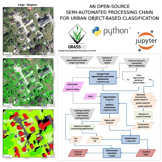
This study presents the development of a semi-automated processing chain for urban object-based land-cover and land-use classification. The processing chain is implemented in Python and relies on existing open-source software GRASS GIS and R. The complete tool chain is available in open access and is adaptable to specific user needs. For automation purposes, we developed two GRASS GIS add-ons enabling users (1) to optimize segmentation parameters in an unsupervised manner and (2) to classify remote sensing data using several individual machine learning classifiers or their prediction combinations through voting-schemes. We tested the performance of the processing chain using sub-metric multispectral and height data on two very different urban environments: Ouagadougou, Burkina Faso in sub-Saharan Africa and Liège, Belgium in Western Europe. Using a hierarchical classification scheme, the overall accuracy reached 93% at the first level (5 classes) and about 80% at the second level (11 and 9 classes, respectively).
This work was funded by the Belgian Federal Science Policy Office (BELSPO) (Research Program for Earth Observation STEREO III, contract SR/00/304 - as part of the MAUPP project and by Moerman research program of ISSeP SmartPop project.