-
Notifications
You must be signed in to change notification settings - Fork 16
Road indicators
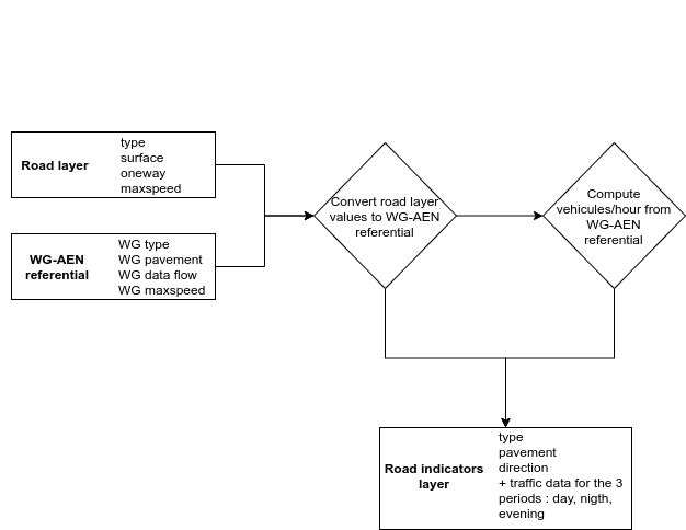
GeoClimate offers a processing chain to compute road traffic data based on the table Tool 2.5 (WG-AEN method) from Good Practice Guide for Strategic Noise Mapping and the Production of Associated Data on Noise Exposure Version 2 13th January 200. The chain uses the GeoClimate road layer and a configuration file that contains :
- a list of relations between the WG-AEN road types and the input road layer types
- the Tool 2.5 flow data by WG-AEN road types for the 3 periods day, night, evening
- the maximum speed value according the WG-AEN road types,
- the CNOSSOS-EU pavement codes according the surface values available in the road layer
For each road geometry, the road traffic algorithm wraps the WG-AEN road type. If a WG-AEN road type is found then
- the maximum speed value is extracted only if its value is not available on the road layer
- the surface value is wrapped with the CNOSSOS-EU pavement codes
direction value from the road layer, WG-AEN road type and flow data from the configuration file are intersecting to compute the number of light and heavy vehicles per hour for the 3 time periods : day (06:00-18:00), evening (ev) (18:00-22:00) and night (22:00-06:00).
The result is stored in a new layer that contains for each road :
- the WG-AEN road type,
- the number of light vehicles per hour for day,
- the number of heavy vehicles per hour for day,
- the light vehicles speed for day,
- the heavy vehicles speed for day,
- the number of light vehicles per hour for night,
- the number of heavy vehicles per hour for night,
- the light vehicles speed for night,
- the heavy vehicles speed for night,
- the number of light vehicles per hour for evening,
- the number of heavy vehicles per hour for evening,
- the light vehicles speed for evening,
- the number of heavy vehicles per hour for evening,
- the slope (in %) of the road section,
- the direction of the road section. 1 = one way road section and the traffic goes in the same way that the slope definition you have used, 2 = one way road section and the traffic goes in the inverse way that the slope definition you have used, 3 = bi-directional traffic flow, the flow is split into two components and correct half for uphill and half for downhill

Figure 3. Processing steps to compute a road traffic flow based on road types
GeoClimate - documentation 2020 - 2024 -
This work is licensed under a Creative Commons Attribution-ShareAlike 4.0 International.
